
Drawing a nonpartisan NC map
Drawing a nonpartisan NC map
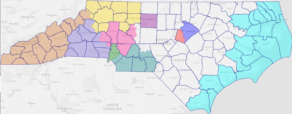
An annotated congressional district map drawing from an independent

An annotated congressional district map drawing from an independent
North Carolina’s congressional districts have had perennial problems with gerrymandering by both parties. The last congressional district map, which I analyzed in this article, was only in place for a single cycle; North Carolina needs a new map. One has been passed by the legislature.
In what follows, I will step through my reasoning in drawing a North Carolina congressional district map without taking into account race or partisanship. This is, from my perspective, a necessary first step before analyzing the map; you have to understand what a fairly drawn map might look like first. My next article on the subject will look at the new actual map, which (like most maps drawn by North Carolina state legislatures in my lifetime) is probably much less fairly drawn.
Use of existing subdivisions
The main consideration I have in mind is making districts that are compact both in human and geographic terms. North Carolina is divided into cities and counties, with several distinct geographic regions (e.g., mountains, coastline) and three major population centers (the Triangle, the Triad, and Charlotte).
Finding the seeds of each district
Keeping counties and cities largely intact means that most districts can be identified by a major population center. Counties are the larger political unit, so I started by identifying the fourteen largest counties as possible district centers.
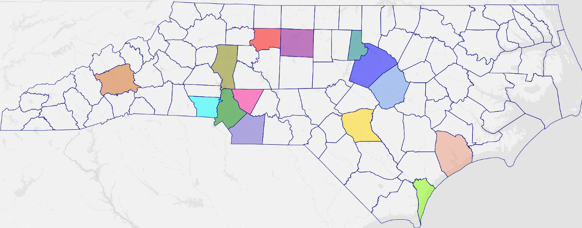
Wake and Mecklenburg counties are too large to fit inside a single congressional district. On the city level, this is also true for Charlotte, which must be divided between at least two districts. Raleigh, on the other hand, can be kept intact. Cutting Wake carefully avoids breaking up any cities; Raleigh can be contained entirely inside one district, and the southwestern Wake County suburbs can anchor a separate district.
This gives us our first two districts and two new population centers. Eliminating the centers that are small enough and close enough together to potentially be combined, we have two districts and seven district cores that need to be expanded into full districts.
Natural geographic communities
There are two key regions of North Carolina that share common and distinctive geographic interests: The Appalachian mountains and the coastline. These areas are physically, culturally, and economically distinct from the rest of the state. The coastal counties deal with hurricanes, tourism, fishing, and a combination of wealthy retirees and impoverished locals. The mountain counties also deal with tourism and a combination of wealthy retirees and impoverished locals, but have winter weather instead of hurricanes.

As of the latest official census figures, the mountain counties have a total population of 786,864 — almost exactly corresponding to a single district. The coastal counties have a population of 1,031,930. This means either one coastal district and one partially coastal district, or two mostly-coastal districts.
Appalachia from west to east
From a compactness perspective, it makes sense to trim the northernmost part of the Appalachian mountain range from the mountain district. The Appalachian Regional Commission also identifies a significant additional portion of western North Carolina as part of the cultural Appalachian region, as far east as Forsythe County; appending the remaining highlands counties to those gives us a second oversized Appalachian district with a population just over a million.
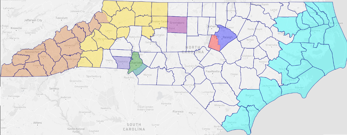
Trimming this down to a compact district (basically the 421 corridor) means trimming the southern counties, which then logically need to be appended to the major population center in Gaston. Trying to maintain some level of compactness and avoid dividing cities, I decided to include Hickory but exclude Lake Norman, which means cutting across an extra county line.
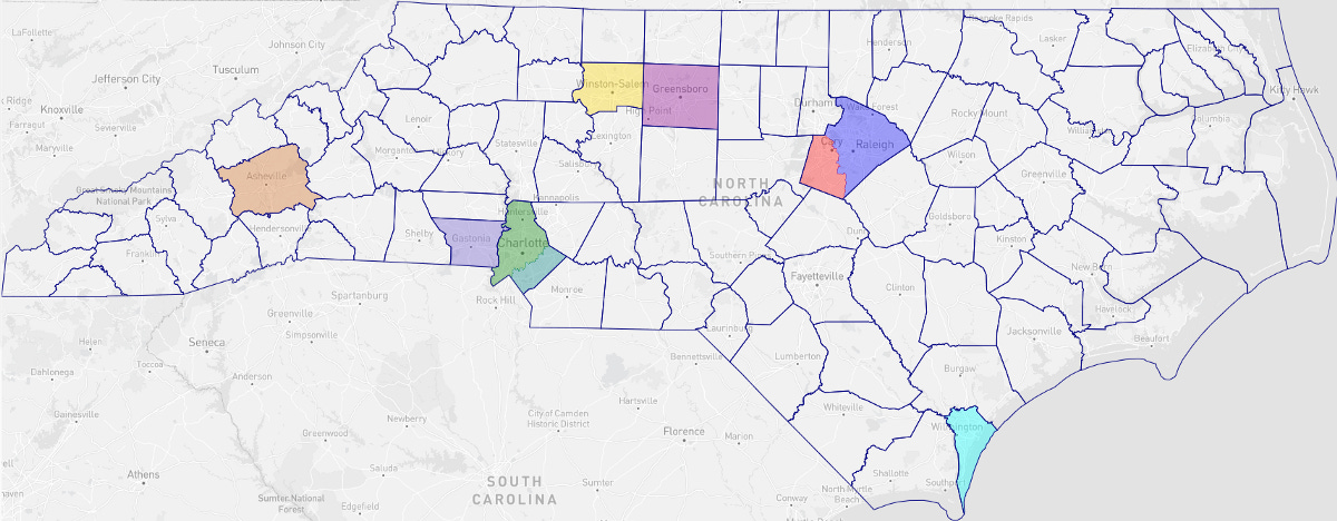
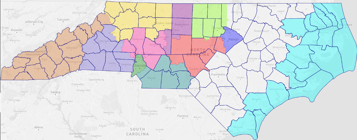
The Charlotte area
Our last Appalachian district ended up spilling into the western Charlotte suburbs, with a population split between Charlotte suburbs and more rural areas westwards. The remaining suburban Charlotte population is still too large to fit in a single district. This tells us we need two other Charlotte area districts, one against the southern border and one squeezed in between Charlotte and Winston-Salem.
The Triad
Moving eastwards, we can include the rest of the Triad in a single district, along with Rockingham County in order to help the next district be compact. This district is slightly awkwardly shaped. This is partly justified by the fact that the two county lines it crosses are also awkwardly crossed by the city of High Point (one of the few cities that crosses county lines in North Carolina).

The Triangle
The three cities of the Triangle include Durham, Chapel Hill (Orange), and Raleigh (Wake). The big choice here is whether to combine Durham with Orange or the remainder of Wake; combining it with Orange allows for slightly more compactly-shaped districts.
Revisiting the coast
There are two basic choices with the coastal counties: Either divide the coastal counties into northern and southern parts, or have one very long district that concentrates the Atlantic coastline. Most of the northeast coast is sparsely inhabited; thus, we can make a southern coastal district with all of the major coastal population centers, and attach the sparsely inhabited northern coastal counties to the rural northeastern areas.
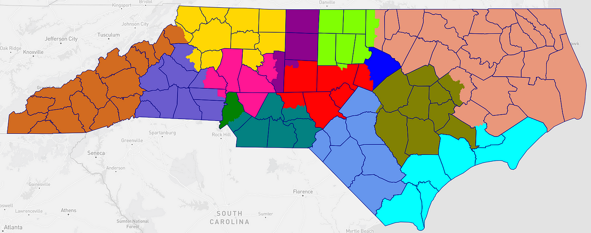
The remaining area can be very easily divided into two fairly compact districts, one anchored by Fayetteville and one with a center near Goldsboro. It’s worth noting that while I did not draw it with race in mind, the northeastern district includes every county in North Carolina with an African-American majority. That said, it is only 35% African-American as a whole, and a politically competitive district. As I’ve discussed before, drawing congressional districts with an African-American majority in North Carolina requires dividing county lines carefully.
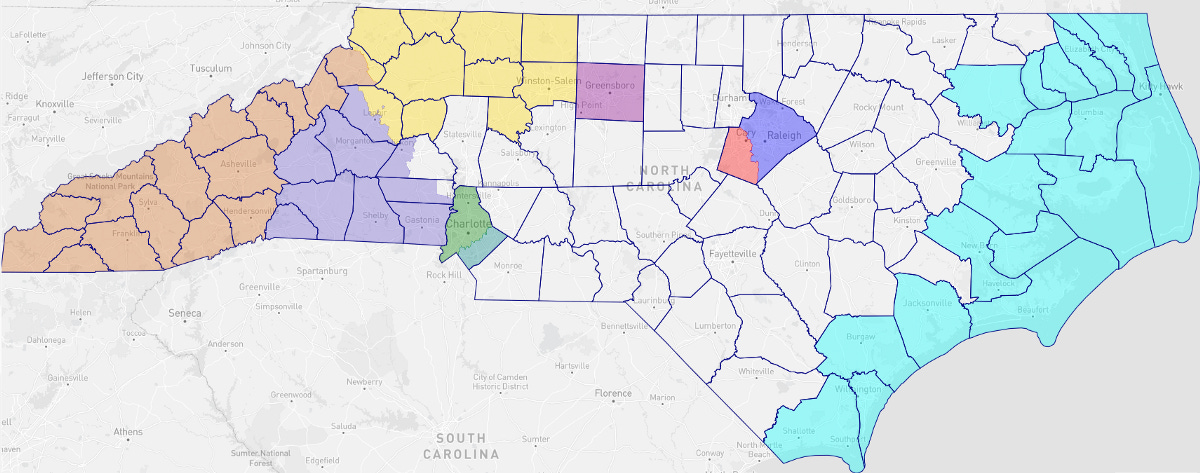
Reviewing the map
There are a couple of warning signs to look for to be able to spot gerrymandering at a glance: Unnecessary divisions of counties and cities, a very linear network of adjacencies, and non-convexity (particularly when the non-convexity isn’t the result of a county boundary). One particularly strong sign of gerrymandering is radial spokes heading outwards from a dense population concentration.

In this case, most non-convexities are driven by county boundaries having non-convexity, or by drawing boundaries within a county that avoid splitting cities. There are two districts that contain very linear network sections, but they can be explained by physical geography (coastal district and highland mountain district). There are 14 county splits, which includes the one extra split made keeping both Lake Norman and Hickory in one piece.
It’s worth noting that this map — drawn without regard to race or partisanship — has two majority-minority districts and seven districts that could very plausibly be competitive in a strong year for either party. Because Democratic voters are more tightly concentrated than Republican voters, it does have a slight Republican lean, as most fairly drawn maps with single member districts will.