

The 2021 NC congressional map
A nonpartisan analysis of a partisan gerrymander

A nonpartisan analysis of a partisan gerrymander
Here is the newly-passed North Carolina congressional district map. It is a partisan gerrymander. I can tell this at a glance without having to consult the estimated election results. North Carolina has a long history of gerrymandering (by both parties), including the previous map.

The basic red flags to be aware of whenever looking at a proposed district map are this:
Long “snake-like” districts, such as the 12th district and the eastern part of the 11th district.
Many districts converging on a single population center and spreading outwards radially (e.g., as seen with Charlotte, the Triad, and the Triangle).
Non-convexity (indented boundaries), especially when those indentations either break county lines or circle around entire counties.
Unnecessary divisions of counties and cities, such as seen in Wake, Mecklenburg, and Guilford counties, as well as Greensboro and Charlotte.
In the previous Congressional map, snake-like districts were the most obvious problem. Here, the most readily apparent problem is cracking - unnecessarily dividing major population centers in order to dilute their influence.
District by district
I’ll break the irregularities up into groups: Charlotte, the Triad, the northeastern districts, and the Triangle districts. For some useful comparisons, I have drawn a map of my own as a preliminary exercise. Aside from the minor irregularity in what part of Watauga County the state legislature chose to exclude, the western 14th district is very similar to what I drew on my own; while not perfectly compact, it is a very natural district to draw given the physical geography of the state.

I drew the above map without paying attention to partisanship, only population totals — trying to keep cities and counties intact and taking into account a small amount of North Carolina geography. Note that no county is divided into three parts, and only two cities are split between two districts (Charlotte and … of all things, New Bern, the latter of which I could probably have avoided with a little more work). I fit the Triad into two districts, the Triangle into arguably two or three, and the Charlotte area into four districts.
Charlotte
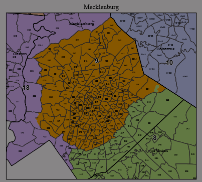
Since Mecklenburg County has less than 1.5 million residents, dividing Charlotte between three different districts (instead of two districts) is very obviously a ploy for partisan advantage. Depending on the details, splitting up a major city and having districts radiate outwards from a population center can either be performed as a Democratic gerrymander or a Republican gerrymander depending on how strongly the city is packed and cracked, but the radial pattern is characteristic of gerrymander.
The Charlotte area is split between a total of five districts, as it was in the previous partisan gerrymander; it would be natural to contain Charlotte and its immediate suburbs in three or four districts. These districts stretch from the mountains to Winston Salem to the sandhills — which is to say that they aren’t quite as far-flung as in the previous district map, but still stretch quite far from Charlotte.
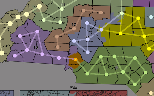
The Triad

The Triad cities are Winston-Salem, Greensboro, and High Point, which are mostly contained in Guilford and Forsyth counties. (High Point has small extensions into Davidson and Randolph counties). It is not quite possible to fit both Guilford and Forsyth counties in a single district together, but there is no good excuse for cracking Guilford into three pieces and dividing the Triad between four different districts. Guilford is small enough to fit inside a single Congressional district!
The fact that the 10th district has two partial counties in a line extending outwards, and that the 12th district is only connected by a partial county, are also major red flags. Whole counties that are only connected in a linear fashion are a warning sign; when districts connect a linear chain of pieces involving partial counties in the middle, bypassing the rest of the closer county, this is clear proof of gerrymandering.
The northeastern districts

First, I’ll note the very obvious fact that the division of Onslow County is decidedly non-convex, and it could easily have been done in a convex way. This is a minor issue, however. It’s also worth noting that past districts corresponding to the new 1st and 2nd districts have been the subject of multiple lawsuits on the topic of racial gerrymandering; this is an area of the state that is home to a large African-American population.
What’s more interesting is the second district has several odd protrusions — stretching westward along the northern border in a line of three counties in a row, poking into the middle of the first district, and swinging around Pitt County in order to get all the way to Goldsboro in Wayne County.
The Triangle

The Charlotte area and the Triad are obviously cracked. The Triangle, by contrast, is obviously packed, with the 6th district consisting of Chapel Hill, Durham, and Cary being designed to concentrate the Triangle’s highly educated (and very liberal) population into a single very safe district.
There are two red flags here. First is the fact that Wake County is divided into three parts is an immediate red flag. Wake County’s population merits dividing the county into two parts; it does not merit dividing the county into three parts. Second, the 7th district contains no less than four partial counties, sprawling from Thomasville in Davidson County to Morrisville in Wake County.
Summary
Like every other congressional map drawn for North Carolina in my lifetime, the latest North Carolina district map is an obvious gerrymander. This is readily apparent without looking at the map from a partisan perspective or estimating likely partisan balance; it is obvious in the structure of the districts themselves.
Most notably, this district map unnecessarily cracks the three largest counties in North Carolina into three pieces each. Similarly to the previous congressional map, it contains some characteristically linear districts that connect distant populations and bypass closer counties while doing so.